St Leonard’s Hospital & POW Camp

St. Leonard’s Hospital was built as a wartime hospital for American and Canadian military forces who flew their injured servicemen into Hurn Airport. A mix of wooden and brick buildings were built in 1942. A record layout plan from 1943 made available by the Ringwood Meeting House & History Centre (see photo) shows the original layout and details that the Hospital was built for 750 and accommodated 545 staff.

An amendment to the 1943 plan dated June 1945 maps a POW tented enclosure to the south of the main hospital buildings. The POWs are reported as working in the hospital. In 1950 with the advent on the new National Health Service, St Leonards became a hospital for the elderly with 350 beds.

Most of the WWII buildings were reportedly demolished sometime in the 1960s and all that remains are their concrete bases, though several are recorded as still standing along with the site water tower.

If you have any other information on St Leonards, including memories, photos from then or now and would like to share them, please upload them to this Portal.

Starfish Decoys – Denny Lodge Starfish Decoy SF17B

In addition to the construction of anti-aircraft and searchlight batteries in an attempt to further protect the civilian population against enemy air raids, an elaborate network of deception sites were installed across the New Forest, including the construction of Starfish decoy sites. These sites were designed to simulate a city at night, using strategically placed lights and fires. Six such sites were built around Southampton in order to try and mislead German bombers and cause them to drop their bombs on unoccupied countryside instead of the city. Two such sites, SF17A at Longdown and SF17B at Denny Lodge, were built in January 1941.

Starfish Bombing Decoy SF17B was built at Hilltop Beaulieu in 1941.

In 1942, a QL site (simulating camp lighting) was also established at the decoy location, which remained in use between 1942 and 1943.

The National Monuments Record records 245 Starfish sites in England. There are no examples of complete sites, although occasionally the control bunker may be extant remains. The bunker at SF17B was probably removed at the end of the war. However six large rectangular firebreaks and a large curving bank potentially survive at the site.

The lack of bomb craters or depressions on the ground or visible in the Lidar data does create questions on how succesful this decoy was.

A period film about visual deception talks about decoy sites and the differant types of decoys.  You can see the film on the IWM website: http://www.iwm.org.uk/collections/item/object/1060020970

Some interesting articles


Still watching over Ibsley – RAF Control Tower

Please note that the watchtower is on private land with no public access. It can be seen from the road

Today, the former site of RAF Ibsley is mostly unrecognisable.  After military control and a successful stint as a race circuit managed by Ringwood Motor Cycle and Light Car Club that operated till 1955 the area became a major quarrying area. Though most of RAF Ibsley is now hidden under quarries or landscaped lakes (known as Blashford Lakes), various echoes of its past still haunt the area. One of which is the surviving shell of the Watch Tower (Type 518/40 ‘Watch Office with Meteorological Section’) believed to be the only example in the country whose floors and balacony were formed entirely from concrete, and survives unaltered.

Photos from 2007 to 2012 show the various changes that have happened including the loss of the metal window frames and the blocking of the ground floor windows with Breeze Blocks to control vandalism and protect the building as a bat roost.

In 2018 with support from the National Lottery Heritage Fund through the Our Past, Our Future Landscape Partnership Scheme a detailed laser scan was undertaken of the building to aid with any future conservation plans and to ensure an accurate point in time record could be used for ongoing monitoring. The following video is a fly through of the building using the laser scan results.

Laser Scan Animation of the RAF Ibsley Control Tower

Laser Scan animation of RAF Ibsley control tower from Archaeovision on Vimeo.

You can find out more about Ibsley Airfield in this overview article, which has links to other articles relating to Ibsley Airfield.

Stone Point Battery

Recent storms at Lepe Country Park in February 2014 caused cliff collapse along the shore, this collaspe revealed a previously burried gun pit in profile. with sandbags and metal work. the pit is very simialar to one excavated by the project at Park Farm, Beaulieu (Here).

research in the war diaries identified documentary evidence for this site and its activity (WO 192/306). A detailed facility report informs us that there was one Barr and Stroud Rangefinder No.12, three  6inch B.L.Mk.VII. guns and three Fortress Projectors Mk.V. searchlights operating at the site with 102 men. The site was part of the Calshot Fire Command along with Calshot Battery and Hook Bungalow Battery under 539 (Southampton) Coast Regt. R.A(R.H.Q). Further detail covers beach and land targets and a distribution of Fire Scheme for night and day engagements.

You can find out more about Lepe during D-Day and WWII here: D-Day at Lepe


Stoney Cross Airfield – Overview

A 1946 RAF aerial image of Stoney Cross airfield and 1946 asset plan of the site compiled by the Air Ministry Works Directorate in preperation for closing and returning the site to original landowners.

Stoney Cross opened in November 1942 and served the Royal Air Force and United States Army Air Forces Ninth Air Force.

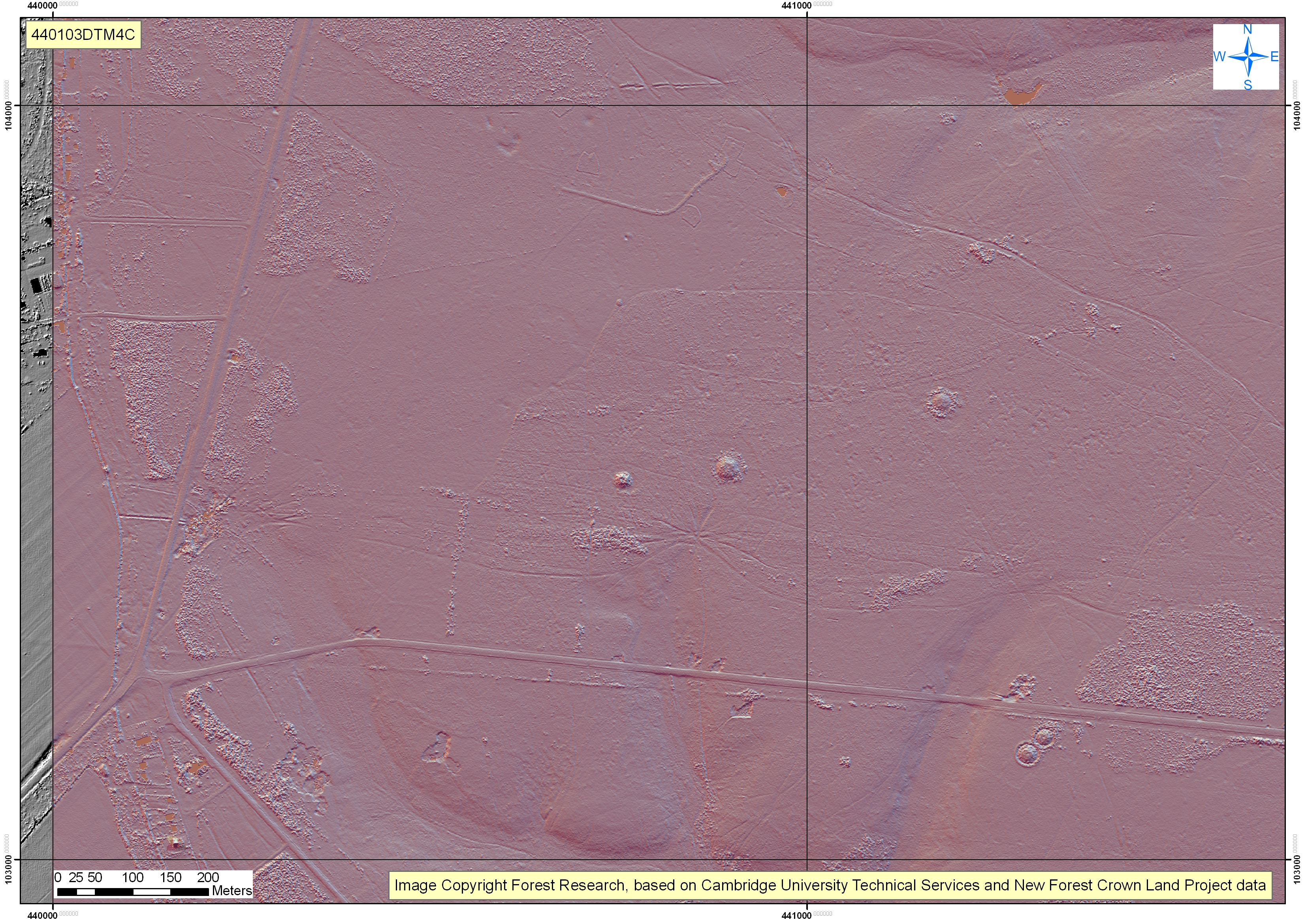
Due to its location and the topography of the land, the airfield had an unusual runway layout which nonetheless conformed to the Class A airfield standard set by the Air Ministry. It had one main runway, aligned 07/25, with two secondary runways, aligned 01/19 and 15/33; a large number of frying-pan type dispersal pads with a few loops connecting to an enclosing perimeter track, of a standard width of 50 feet.

Although officially opened in November 1942, RAF Fighter Command No. 239 Squadron’s P-51B Mustangs that arrived in January 1943 followed by those of No. 26 Squadron had to operate amid on-going construction work. After the Mustang squadrons moved out in April 1943 there was additional construction at the airfield until August 1943.
In August, RAF Bomber Command No. 297 Squadron took up residence. Early in March 1944 the RAF moved out and the USAAF Ninth Air Force moved in to use Stoney Cross as a forward base for tactical fighters.
Stoney Cross became known as USAAF Station AAF-452 for security reasons during the war, its USAAF Station Code was “SS”.
The 367th fighter group entered combat on 9 May 1944, attacking railways, bridges, hangars, and other targets in western France, and escorting bombers that struck airfields, marshalling yards and other facilities in the same area.
In the latter half of June the 367th switched to ground attack missions supporting First Army ground forces in France.
On 6 July the 367th Fighter was moved to nearby RAF Ibsley to make way for the 387th Bomb Group.
When the Americans moved into France by 5 September 1944, Stoney Cross reverted to RAF Transport Command control and, at first, the station was used for the assessment and repair of gliders recovered from the Normandy operations.
Following the end of hostilities in Europe, Stoney Cross was developed as a major staging post for RAF transports flying to the Far East. This activity was gradually reduced and by December 1946 the remaining units had transferred to RAF Manston. However, Stoney Cross was retained on a care and maintenance basis until January 1948 when the airfield was released back to its pre-war owners.
A number of APs (Aerial Photographs) of sites in the New Forest, taken during or just after WWII, have become available (from English Heritage) via the American Air Museum website.  We are adding these to the online archive as they become available. We have had to reduce the size of some of them, to see them at full resolution visit www.americanairmuseum.com.
There are numerous articles about Stoney Cross Airfield which we have tried to pull together here as potential further reading:

Airfield WWII activity

Strodgemoor Volunteer Rifle Range – Burley

Historic Ordnance Survey maps from the second half of the 19th century show a number of rifle ranges scattered about the New Forest. It is still possible to see visible traces of these ranges surviving at Long Bottom, Lyndhurst, Burley and Brockenhurst.

The ranges at Lyndhurst, Burley and Brockenhurst appear on the 1870 historic OS maps as Volunteer Rifle Ranges and form part of Napoleonic activity in the New Forest you can read more about the general history of the Volunteer Rifle Ranges and their setup on the Lyndhurst White Moor Range page. The Longbottom Range was set up later in 1895.

At Strodgemoor Bottom you can still see the faint mounds from the firing off points, and the earth mound of the target butts aligned running north to south. The 2011 Lidar image shows these clearly arranged across Strodgemoor.

There is also a small concrete shelter/bunker associated with the range, but this is later activity from when the range was in use during WWI or WWII. The New Forest Training Area Map from 1943 marks the Strodgemoor Range as an active range.


Submarines in the New Forest?

As you walk along Hampton Ridge you may notice numerous earthworks and occasional concrete remains hinting at some of the area’s history. One of the most prominent features is a huge earthwork that looks like a large round barrow. This is the site of the Ministry of Home Security Target, known locally as the ‘Sub Pens’, once part of the old WWII Ashley Walk Bombing Range that once covered most of the landscape in this area of the New Forest.

This earthen mound covers a large re-enforced concrete structure built around 1942 and measuring 79ft by 70ft and 12ft high on a heavy duty foundation pad and at a cost of £250,000. After the war and when the range closed the structure was buried following failed attempts to demolish it. If you walk to the top of the mound you will notice a flat top and concrete edges beginning to show where soil has eroded.

The site is locally referred to as the ‘Submarine Pens’. We believe this name arose during the testing of the Grand Slam bomb as those involved in the trails were told that the target was built to replicate the German Submarine Pens built along the French Coast, one of the main targets for the bomb.

Research in the War Diaries and papers held at the National Archives has revealed that the target was built by the Ministry of Home Security to test various concrete mixes, steel re-enforcement and to test potential public air raid shelter designs. The document reference DSIR 27/29/ARP315, Construction of a R.C. shelter at Ashley Walk. The control of concrete quality. By A.R. Collins.

Following a large amount of personal research Henry Cole has pieced together the story of this target and the site that dominates the old Ashley Walk Bombing Range.  The pdf can be accessed here

We have created A 3D computer animation of the construction of the target based on the records from the National Archives

Ministry of Home Security Target (Sub Pens)
by newforestarch
on Sketchfab

Geophysical Analysis:
The project team working with Wessex Archaeology and English Heritage have conducted some further investigation in to the ‘Ministry of Home Security Target’ using various non-intrusive and non-destructive geophysical techniques including; Electrical Resistivity Tomography, Ground Penetrating Radar, Magnetic Survey and Earth Resistivity Survey. Due to the construction methods used to build the target these techniques are being tested to see what results they return and how they support or further our knowledge gained through archive research. You can read the final results: here

Once we have built up a picture on how the different techniques behave we can then look to use them on several underground sites the project has identified where less additional information is known and little has revealed itself through archive research.

The Ashley Walk area is a SSSI (Sites of Special Scientific Interest) and it is illegal to conduct excavations without proper permissions.  There has however been some ‘night digging’ into the mound and whilst the survey team were on site an unmarked envelope was found one morning. In it were a number of photos showing the inside of part of the structure taken from this excavated pit.  You can see these photos by following this link to the Forestry Commission’s Volunteer Rangers Website.

If you have any old photos or stories of the target or any from Ashley Walk please let us know or share them with us on this Portal.

Further Reading

On this site the Ashley Range Overview page has links to pages about the other targets on the range.

Supermarine Southampton: Showing the Royal Air Force Flag

The Supermarine Southampton was a 1920s British flying boat designed by R J Mitchell, one of the most successful flying boats of the interwar period. Based on the Supermarine Swan, it was a twin-engine biplane flying boat, with the tractor engines mounted between the wings. In total 83 were built between it’s first flight on 10 March 1925 and 1934.

Supermarine Southamptons first entered RAF service in August 1925 with No. 480 (Coastal Reconnaissance) Flight at RAF Calshot. In a series of “showing the flag” flights, the type quickly became famous for long-distance formation flights; the most notable was a 43,500 km (27,000 mi) expedition in 1927 and 1928. It was carried out by four Southamptons of the Far East Flight, setting out from Felixstowe via the Mediterranean and India to Singapore.

FIlm footage available from British Pathe shows one of these ‘Showing the Flag’ trips with four Southamptons leaving from RAF Calshot for a tour of Baltic Sea Ports in 1930.

Showing the Royal Air Force Flag, 1930

FILM ID:721.26

Full title reads: “Calshot. ‘Showing the (Royal Air Force) Flag’ 4 of our mighty flying boats leave for tour of Baltic sea ports.”

Calshot, Hampshire.

Pan along line of four flying boats (currently with wheels on) as they sit on the concrete in front of aircraft hangers. The planes are being prepared for their long flight. The RAF Planes are moved out onto the water and slowly make their way up to take off speed. We see the planes flying off to the Baltic in formation.

Surviving Mulberry Beetles

During the planning for the assault phase of the invasion of Europe (D Day), it became clear that the early use of a major port (or preferably ports) would be crucial to ensure the reliable supply of troops and materiel critical to making the invasion a success.  This presented a number of challenges, among which were the likely heavy casualty rates in attacking a port directly (as demonstrated at Dieppe in 1942), and the risk that the port would be rendered inoperable before capture by enemy action or the attack itself.  It was therefore decided that two artificial harbours (codenamed ‘Mulberry’) would be constructed and then towed across the English Channel to Normandy, almost literally in the wake of the invading forces, to be assembled at beaches Omaha and Gold.

The Mulberry Harbours consisted of a number of elements, each of which was crucial to the functioning of the whole.  These can be broadly categorised into two groups:

  • Breakwaters used to create a sheltered area in which ships could load and offload.  These consisted of blockships (‘Corncob’), concrete caissons (‘Phoenix’) and floating steel barriers (‘Bombardons’);
  • Floating pierheads and roadways (‘Whales’), which by falling and rising with the tide facilitated the two-way movement of troops and materiel from the ships to the shore.  The roadways were supported by floating pontoons made of steel or reinforced concrete (‘Beetles’).

Elements of these Mulberry Harbours were built at various points along the New Forest coast; at Stone Point (Lepe), along the Beaulieu River and at Marchwood Military Port including Whales and Beetles.

39 Beetles constructed at Marchwood Military Port still survive today and lie along the foreshore between Hythe and Marchwood. These units were surplus to requirement and were not towed over to the Normanday Beaches, but were recycled firstly as breakwaters and then as coastal defence to protect reclamation areas.

For more information on the site a recent report on the Beetles by masters’ students at the University of Southampton can be downloaded here

You can find out more about the New Forest’s vital role in D-Day from Mulberry Harbour, to holding camps, road widening, advanced landing grounds, PLUTO and Embarkation by visiting our main page on D-Day in the New Forest.

Taddiford Gap Pillbox

A pillbox (variant) is visible in a farmers field behind Barton Cliff. This is not a Type 23 as this requires an integral open annex and mounting for a light machine gun.

This pill box would have been linked with additional ones along the coast, which have now disappeared and ones further inland such as Braxton and Ashley.

The pill box is visible from a public footpath.

PLEASE NOTE THIS PILLBOX IS ON PRIVATE LAND. THERE IS NO ACCESS WITHOUT LANDOWNERS PERMISSION

If you have anymore information about this pillbox please add your comments below or contact us on archaeology@newforestnpa.gov.uk

If you have anymore information about this or other local pillboxes please add your comments below or contact us on archaeology@newforestnpa.gov.uk

Further New Forest Pillboxes

Milford on Sea

Braxton

Ashley

Redbridge

Hinton

Breamore