

The New Forest Training Area Map, 1943
Author: NFNPA Archaeology
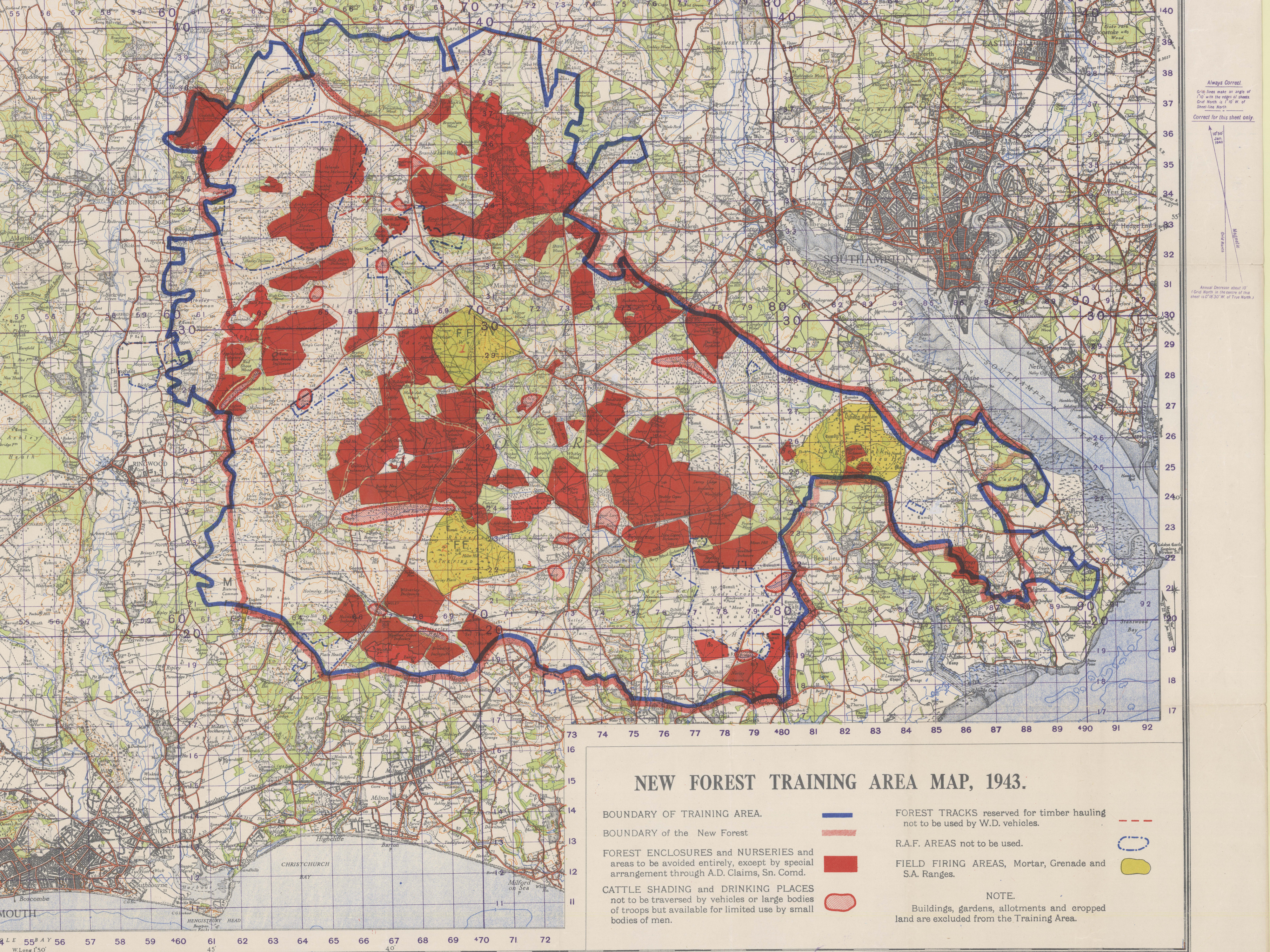
The New Forest Training Area Map, 1943 held in the New Forest Heritage Centre’s Special Collections is an amazing resource helping to pick apart some of the Second World War activity in the New Forest.
The map created by the Geographical Section, General Staff No.3907 and published at the War Office is produced to show specific shaded training areas within the New Forest alongside protected areas for local residents and the commoners animals.
The Key at the bottom of the map reveals that the map includes
- Blue (Line) – Boundary of Training Area, note that this encloses more area than the New Forest Boundary
- Red (line) – Boundary of the New Forest
- Block Red (area) – Forest Enclosures and Nurseries as areas to be avoided entirely, except by special arrangement through A.D. Claims, Sn. Comd.
- Diagonal red lines (area) – Cattle Shading and Drinking Places as areas not to be traversed by vehicles or large bodies of troops, but available for limited use by small bodies of men.
- Dashed Red (Line) – Forest tracks reserved for timber hauling and not to be used by War Department vehicles
- Blue dot dash (line) – Encloses RAF areas not to be used
- Block Yellow (area) – Field Firing Areas, Mortar, Grenade and Small Arms Ranges
The map also notes that Buildings, Gardens, Allotments and cropped lands are excluded from the Training Area.
Points of Interest for the large firing areas:
- Brockenhurst – Tank Training
- Acres Down –
- Dibden –
- Whitemoor at Lyndhurst not included, even though it had a huge amount of use in WWI and also a series of press photos from the Northumberland Fusiliers training there (Potentially just a press opportunity) – 2nd Battalion Northumberland Fusiliers training in Lyndhurst
Points of Interest for the small firing areas:
- Brockenhurst Weirs Rifle Range
- Burley Strodgemoor Rifle Range
- Two ranges marked at Longbottom
- Range just west of Fritham
Points of Interest for the RAF areas:
- Stoneyford Pond east of Beaulieu included – Starfish Decoy site
- Longdown included – Starfish Decoy site
- Beaulieu Airfield
- Small area north of Norley – Decoy site
- Stoney Cross Airfield
- Holmsley South Airfield
- Ashley Walk Bombing Range
- Millersford & Turf Hill Static Explosives Experimental Site
- Ridley Plain – Decoy airfield site
Search terms:
- New Forest Training Area Map, 1943
- Training Area
- WWII Training Areas
Date: 1943