

D-Day at Lepe Beach


")
")
")
")
 being washed by the waves. These covered the beach to prevent tanks sinking into the sand during loading (Photo taken 2012)")

 rearranged by the waves. These covered the beach to prevent tanks sinking into the sand during loading (Feb 2014)")
.")
.")


D-Day & Lepe a Brief Summary
On the 6 June 1944 thousands of troops with their vehicles and supplies left Britain via locations such as Lepe Beach in the New Forest for the beaches of Normandy. This was D Day, the start of the great campaign to liberate Europe and to bring the Second World War to its end.
Survivals at Lepe
A birds eye view of the extensive features that were designed and built to support Mulberry and D-Day at Lepe.
3D Model of Lepe Today that you can explore
-
- The concrete floor remains of the site buildings used by construction workers and the military. They are dotted about in the Country Park area.
- Water Tower Base used for water purification, required because so little fresh water was available on site.
- Construction Platforms where the caissons were constructed. Today, although parts are storm damaged, the platforms run for 374 metres and are 11m wide and 1.3m high. The platforms were large enough to construct all six caissons simultaneously, reflecting the urgency of the work.
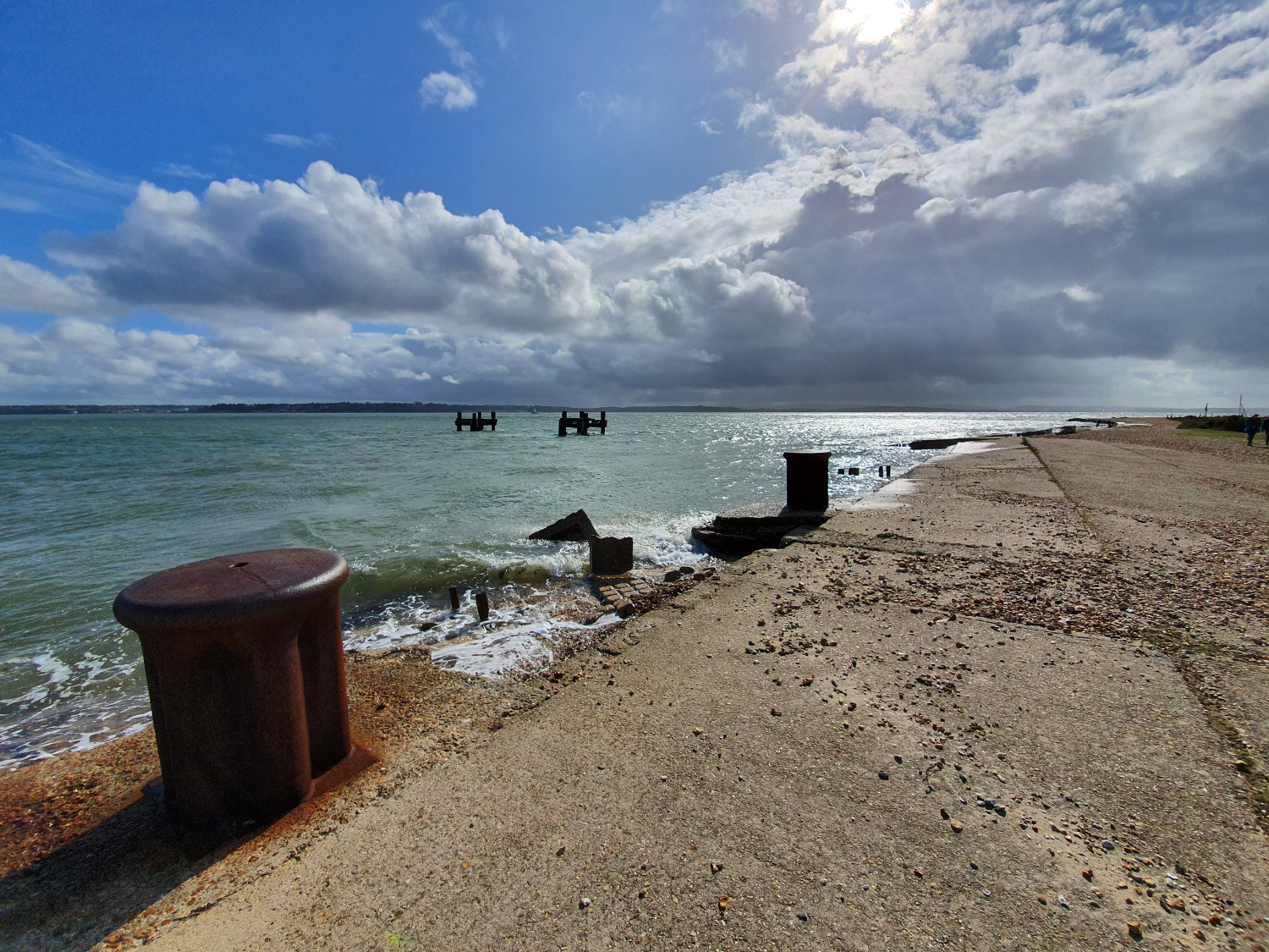
- Beach Hardening Mats which resemble huge bars of chocolate, were held in place by a series of iron hooks. They were laid out to strengthen the beach enough to take the weight of the tanks and other vehicles being driven onto landing craft.
- Dolphins forming part of the pier head used to load ships departing for Normandy.
- Bollards used to tie up the ships that were being loaded for the invasion.
- Concrete Slipways run from the rolling track walls to the sea. These were used to launch the caissons at high tide
Royal Commission on the Historical Monuments of England Survey 1990
Following severe storms in early 1990 the RCHME were requested to survey the site due to concerns about the weakened structure becoming vulnerable to undermining by tides and coastal underflow. There was real danger that another severe storm would further damage one of the few surviving and best preserved monuments to a major event in recent British military history. The aim of the RCHME survey was to record in detail the full extent and form of all remains associated with the D-Day operations surviving within the area.
A low resolution of the survey map can be found in the images above and You can access an annotated copy of the RCHME report of this survey here: RCHME 1990 Survey
It was hoped that following the survey engineering work could be carried out to stabilise the monument and protect it from further damage. However, this was not to be the case and at some point after the survey the three most eastly Caisson construction platforms were deliberately broken up and left to act as coastal defence for the surviving platforms.
More recently with the support of funding from the Our Past, Our Future a National Lottery Heritage Funded Landscape Partnership Scheme a number of additional projects and surveys have been undertaken.
2018 Channel Coastal Observatory Survey
During 2018 the Channel Coastal Observatory based at the National Oceanographic Centre in Southampton and New Forest District Council undertook detailed laser scanning of the foreshore at Lepe Country Park. This was part of a regional project to survey and record coastal defence which includes the WWII archaeology on the coast at Lepe. This data capture however will allow us to monitor the site going forward and will also allow the creation of digital models for education, interpretation and modelling the history of the area. The results of that survey have been used to create the 3D model of WWII Lepe above as it can be found today. You can read more about the recording work here: Lepe Laser Scanning
2019 Digital Reconstruction
The annotations provide more detail on the Caisson construction and launching process. We will be seeking to add more information and detail to this model. Please get in touch if you are aware of any photos or memories of this important New Forest WWII site. There are no known contemporary photos of the site in use. This model is based on archaeological recording, contemporary war diaries and plans, memories, oral histories, loading tables, known examples from elsewhere and some later aerial photos.
More Information
You can find out more about the New Forest’s vital role in D-Day from Mulberry Harbour, to holding camps, road widening, advanced landing grounds, PLUTO and Embarkation by visiting our main page on D-Day in the New Forest.
You can also discover more about the New Forest Remembers project and access the final report here: New Forest Remembers: Untold Stories of World War II
Detailed Breakdown about Lepe during D Day from National Archive Research
Y-4 – Stores – no descriptions
D-3 – Vehicles for 231 Brigade & Vehicles for 69 Brigade –
231 & 69 Brigades were the assault brigades for Gold Beach landing on Jig and King Sectors respectively
D-3 – Self Propelled Artillery, 231 Brigade
These were 25-pounder Sexton = http://en.wikipedia.org/wiki/Sexton_%28artillery%29; units were 90 and 147 Field Regiment, Royal Artillery.
D-3 – Duplex Drive Tanks, 231 Brigade
Sherman D.D. tanks of the Nottinghamshire Yeomanry http://en.wikipedia.org/wiki/DD_tank
D-2 – AVRE, 231 Brigade Assault Vehicle, Royal Engineers; 6th Assault Regiment, R.E., equipped with modified Churchill Tanks, including some of the so called ’Flying Dustbins’
D-2 – AVRE, 69 Brigade With their Petard Mortars, http://en.wikipedia.org/wiki/1st_Assault_Brigade_Royal_Engineers; they were accompanied by Squadrons from the Westminster Dragoons with their ‘Sherman Crab’ flail tanks http://en.wikipedia.org/wiki/Westminster_Dragoons#Second_World_War.
D-2 – Duplex Drive Tanks, 69 Brigade Sherman D.D. tanks of the 4/7 Dragoon Guards
D-1 – Army Fire Service. We do not know what his was composed of.
Notes.
- The Westminster Dragoons claim to have been the first unit ashore on Gold Beach
- The D.D. tanks were landed directly on the shore due to the rough conditions.
- The loading tables list the Landing Craft by number
- The Canadian Unit the 2nd Canadian Armoured Brigade, which was attached to the 3rd Canadian Infantry Division which formed the core of ‘Force J’ the assault force for Juno Beach, they left the area in April 1944 to prepare for embarkation from the East side of Southampton Water. The embarkation points at Lepe were in constant use for training and for ferrying troops to and from the Isle of Wight, well before the D-Day loading, during this earlier use infantry units were also frequently using the site, not just mechanised units.
The storm that arrived late on Friday evening (14 February 2014) exposed a couple of small brick structures in the beach front car park. Further erosion along the coast caused a possible gun emplacement to start to collapse on to the beach.
Caissons built at Lepe were built by Lovatt Ltd.