Long Bottom Rifle Range

Historic Ordnance Survey maps from the second half of the 19th century show a number of rifle ranges scattered about the New Forest. It is still possible to see visible traces of these ranges surviving at Long Bottom, BurleyLyndhurst and Brockenhurst.

The ranges at Lyndhurst, Burley and Brockenhurst appear on the 1870 historic OS maps and form part of Napoleonic activity in the New Forest and it was believed that Long Bottom was part of the same period of activity. However it doesn’t appear on historic Ordnance Survey mapping until 1895. The range at Long Bottom was first proposed in July 1894, when Colonel Vandeleur made an application for leave to erect a rifle range, to be used by the ‘Fordingbridge and Godshill Company of the 4th Volunteer Batallion Hampshire Regiment’, at Longbottom near Fordingbridge [Western Gazette, page 7, 20.07.1894]. Local resistance to the project led to initial delays, but newspaper references [Salisbury & Winchester Journal, 15.06.1895] show that the range was in use the following year.

The range at Long Bottom was first proposed in July 1894, when Colonel Vandeleur made an application for leave to erect a rifle range, to be used by the ‘Fordingbridge and Godshill Company of the 4th Volunteer Batallion Hampshire Regiment’, at Longbottom near Fordingbridge [Western Gazette, page 7, 20.07.1894]. Local resistance to the project led to initial delays, but newspaper references [Salisbury & Winchester Journal, 15.06.1895] show that the range was in use the following year.

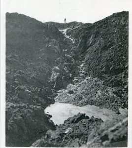
The range at Long Bottom just below Ashley Walk with 8 firing off points positioned every 100 yards towards two targets along with structures for the magazine and markers hut.

Today visiting the site it is still possible to see the firing off points, the concrete target shelter and a brick structure built into the side of the hill originally believed to be the markers hut.

The following research by Bill Flentje questions whether the surviving structure is the Markers Hut or the Magazine and considers the range in more detail comparing it with other ranges around the country rather than just Brockenhurst and Lyndhurst and makes very interesting reading.

The 1898 map, surveyed 1895, shows the range with its original structures, as built that year. These include a ‘Magazine’ next to a ‘Marker’s Hut’. When visiting the range some 10 years ago, I saw no evidence of the ‘Marker’s Hut’, but I did examine the surviving brick arch entrance to what I believe to have been the ‘Magazine’. (Note: the term ‘Marker’s Hut’ in a ‘rifle range context’ normally describes a small shelter [or ‘mantlet’], solely used in connection with iron targets. A ‘Marker’s Hut’ would be erected either next to an iron target [disc marking system] or some 15 yards in front of an iron target, next to the line of fire [dummy target or flag marking systems]. The ‘Marker’s Hut’ would have given protection to the ‘marker’, who would have monitored the fall of shot on the iron target and indicated to the shooter the value and position of each shot). The 1898 map shows two things, firstly, that no iron targets were in use in connection with the Longbottom range. Iron targets were by now considered unsafe in connection with the use of the new .303” cal magazine rifle. Secondly, the ‘Marker’s Hut’ shown on the map was located some 100 yards from the targets. At that distance, the marker would not have been able to see and identify any bullet hit on the target. For these reasons I assume that the cartographer’s use of the term ‘Marker’s Hut’ in this instance is a misnomer – the structure was simply a troop shelter and target store, which was demolished many years ago. What has survived, however, is the ‘Magazine’ and I attach a photo and map of a similar structure, built into the side of the stop butt (backstop) of a rifle range near Worksop in Nottinghamshire. This allows a meaningful comparison with the structure at Long Bottom.

Official W.O. Rifle Range Returns of 1903, list the range as ‘Longbottom’ <S60> [Southern District No. 60] with 4 canvas targets and firing points back to 800 yards. However, the 1898 and 1909 maps show that only 2 target frames were installed, almost certainly in a pit below ground level. The target frames installed in the pit were probably ‘Ralston Dual Canvas Frames’ (image above), produced in Glasgow. When visiting the range, clearly identifiable metal components, once part of such frames, still protruded from the soil along with cogs. The maps do not show any protective earth bank (mantlet) in front of ‘Targets’.  This supports my suggestion that the target frames were erected in a pit some 7 feet below ground level, with only the canvas targets, when raised, visible above ground level. ‘Markers’ were positioned safely within the pit to operate and mark/patch the targets and indicate the score. Could it be the case that some years later the range was ‘modernised’ by simply filling in the pit, while leaving the redundant target frames in situ, which then led to some parts of the structures still jutting out of the ground?

Part of the range upgrade would have been the construction of a wall to support the mantlet, to which a roof once was attached (now demolished for reasons of safety – see below). The space behind the protection of the wall, often referred to as ‘markers’ gallery’, allowed markers to be positioned to operate, mark and repair the targets. The wall was necessary as a different type of target frames, now erected above ground level, had come into use. The targets now in use are likely to have been mounted on ‘Windmill Target Frames’ (Image above), consisting of substantial wooden vertical post, which supported an axle, around which the targets, mounted on a wooden frame, would rotate.

I have no evidence for this, but it seems possible that the range was ‘modernised’ in connection with the drastically increased need of more rifle range capacity during WW1. The new linear mantlet would have allowed the erection of at least four Windmill Frames.

Bill Flentje 2019

The Target Today

As part of the Higher Level Stewardship Scheme it was identified that the degrading rifle target was a danger to livestock and visitors to the site and it was decided that the collapsing lean-to roof should be removed. As well as this, the marker’s hut, used to identify if riflemen had hit their target, was also identified as being in a poor state of repair and the decision was made to undertake conservation works on this brick structure.

Before these works were undertaken, the scheme felt that it was important to record the site in high detail so that archaeologists and historians in the future could refer back to how the rifle target was constructed before it was partially demolished. To do this, archaeologists from the New Forest National Park Authority and the University of Southampton undertook a terrestrial laser scan survey of the site and its surroundings.

This high-tech, high-definition approach helped to record the structure to centimetre accuracy in three dimension and will allow researchers to measure, analyse or even re-construct a replica of this structure in the future.

This animation was created with the help of Archaeovision using the data recorded by the terrestrial laser scanning survey, and provides the viewer with a fly through of the site before the roof was removed.

Napoleonic Rifle Ranges – History Hit Film

This short clip provides a bit more history about some of the Napoleonic rifle ranges that can be found across the New Forest.

Lymington Advanced Landing Ground – Overview

RAF Lymington ALG (Advanced Landing Ground) was constructed in the summer of 1943 in preparation for the invasion of mainland Europe. However, it was not occupied until April 1944 when three US squadrons of the 50th Fighter Group arrived. These squadrons were equipped with Thunderbolt fighters and flew numerous missions over the D-Day period, before they departed to an airfield in France on June 24th. After that only a small holding party remained at the airfield and little flying took place before the site was broken down in spring 1945. There is some suggestion that the airfield was a prototype for construction methods for the airfields that would be built in France, but this is not confirmed.

ALGs were not designed as anything more than temporary airfields. The landing strip was made of steel mesh pinned to the ground with large stakes that could be removed when the airfield was closed. As such they leave little evidence of their past on the ground. At Lymington, this evidence takes the form of a crop mark of one of the perimeter tracks, and a blister hanger that is still in use as a farm store.

A number of APs (Aerial Photographs) of sites in the New Forest, taken during or just after WWII, have become available (from English Heritage) via the American Air Museum website.  We are adding these to the online archive as they become available. We have had to reduce the size of some of them, to see them at full resolution visit www.americanairmuseum.com.

Lymington ALG has had a new Interpretation Panel installed as part of the New Forest Remembers Project. You can find out more: Here

You can find out more about the New Forest’s vital role in D-Day from Mulberry Harbour, to holding camps, road widening, advanced landing grounds, PLUTO and Embarkation by visiting our main page on D-Day in the New Forest.

The Other New Forest Advanced Landing Grounds

Bisterne

Needs Ore

Winkton


Lyndhurst Auxiliary Unit Patrol

Information on this patrol comes from the British Resistance Archive and is compiled by Dr Will Ward CART CIO for Dorset who also volunteers for the the New Forest National Park Authority

Name DOB Occupation  Died
Sgt. J H Adams 03/02/1894 Forester
Pte. George Ben Broomfield 28/02/1904 Forester 1981
Pte. Henry Charles Barnes 18/08/1892
Pte. Frederick C Core 07/08/1880 1946
Pte. Edward Augustus Soffe 31/08/1901 1965
Pte. E H S Wilson 03/04/1919
Pte. J Collins 29/03/1895
Pte. Lionel Benjamin Wren 29/6/1888 Keeper Posted to 9th Bn HG Jan 1943 1948

The patrol names for the west of Hampshire and the New Forest have been identified from National Archives file WO199/3391, but are not divided by patrol. The nominal roll gives the surname, initials, ID card number and address, together with date of birth. The patrols have been arranged according to the addresses and ID card numbers around known patrol leaders. This means the allocations may not be completely accurate. Additional personal information such as first names and dates of death have been added using the 1911 census, Ancestry.com and FreeBMD.com. Some men, particularly those from the Ringwood area where there are several patrols, could not be allocated with any confidence to one patrol or another, so are listed here.

Sergeant Adams and George Broomfield both lived in Forester’s cottages so were likely employed in this role. They lived at Denny Lodge and Lodge Hill respectively. Lionel Wren was a Keeper, an Official appointment, which merited mention in the London Gazette in 1936.

You can find out more about the other New Forest patrols on this site here: Churchill’s Secret Army

Or by visiting the main Coleshill House article here: http://www.coleshillhouse.com/lyndhurst-auxiliary-unit-patrol.php

Lyndhurst Church Gravestone Steps – Improving Access Project

St Michaels & All Angels Church Lyndhurst: Churchyard Improving Access Project

Following the installation of a new safe accessible route to school from the main Lyndhurst carpark through the St Michael’s and All Angels churchyard avoiding the footpath along the main road the old stepped path through the churchyard was fenced off and was slowly disappearing under vegetation. If you looked closely at this old path you would have seen that it was made out of old gravestones. The gravestones have been moved to create the path from elsewhere in the graveyard and they do not contain burials under them.

As part of the original planning approval for the new path a requirement was that the old steps made from old gravestones was to be removed.

The programme of work is being managed by the New Forest National Park Authority, and has been given formal approval by Winchester Diocese and the Planning Authority. It will improve access to the churchyard’s important heritage features and is funded by the New Forest LEADER local action group through the European Agricultural Fund for Rural Development. The churchyard is maintained by New Forest District Council as a closed burial ground and the monuments are technically heirlooms. The church and the District Council responsibilities only require that the moments are safe for public access to the churchyard.

As part of the project the gravestones will all be cleaned and recorded using RTI photography to read the faded inscriptions to help reveal the names of the people they memorialised. The hope is that the names will then be linked back to the burial registers and potentially their original burial location. It will also allow families to re-link their family histories with the headstones in the churchyard. The removed headstones will be used to create benches in the churchyard, but they will all be logged so if you are searching for a specific one we can show you where they have ended up.

Further work has seen the footpath extended to allow easy access to Alice Liddell’s memorial behind the church.

RTI Recording

During July 2019, Archaeovision undertook a Reflectance Transformation Imaging (RTI) survey of the 43 headstones that were removed from the old path as well as another 37 headstones and other engraved stones recovered from the ditch running parallel to the footpath. The 80 headstones were all photographed and processed to reveal the inscriptions and identify some of the lost names and families originally buried in St Michael’s.

Some of the highlights are included in the images above.

You can read a low resolution version of the report here: Lyndhurst RTI Report (warning still large file size 10Mb) or you can request a high resolution version from the New Forest National Park Authority or New Forest Heritage Centre Library.

Alternatively all of the photography results from RTI work undertaken in the graveyard along with the transcriptions can be found hereLyndhurst St Michaels & All Angels RTI

All of the results will be inputted into the spreadsheet of monuments in St Michael’s and All Angels allowing the public to find out who is buried in the churchyard.

Further Work and Information

Three of the monuments in the churchyard are listed and are dealt with as Listed Buildings. These were recently repaired as part of National Lottery Heritage Funding managed by the New Forest National Park and have been removed from the Historic England Buildings at Risk register.

You can find out more about the St Michael’s & All Angels via one of the New Forest History Hit Films


St Michael & All Angels Church Lyndhurst: Churchyard Improving Access Project

Is part funded by the European Agricultural Fund for Rural Development


Leader LogoEU LogoNew Forest Leader - Local Action Group Logo

Example of one of the Graves following RTI

Grave LSMAA171

Here lieth the body of Charles Newbolt who Departed this life on the 20 day of August 1745 Aged 65 years

Also Catherine the wife of John H who died The 7th day of October 1766 Aged 70 years

Matley Heath Archaeology: Drone tour

Join us for a drone tour of Iron Age and Bronze Age sites at Matley Heath in the New Forest. These are just some of the thousands of historical sites we work to protect every year.

Bournemouth Archaeology have been commissioned to undertake a large geophysical survey of the two sites to see if we can learn more about them and the New Forest landscape they reside in. Results to follow.

The area comprises of two scheduled monument areas

Hillfort 400m south of Home Farm

List entry Number: 1017019

The monument includes a slight univallate hillfort situated on the top of a sandy knoll immediately south of a stream within the New Forest. The hillfort is sub-circular in plan and has ramparts 1m in height and 3m in width which enclose an area of approximately 0.3ha. An external ditch up to 3m in width and 0.9m in depth and a slight counterscarp bank are visible around the eastern, western and southern sides of the rampart. On the northern side of the hillfort the rampart utilizes the natural scarp and has no obvious external ditch, although a depression 7m in length, 0.2m in width and 0.3m in depth projects northwards from the base of the scarp. A break in the eastern rampart 7m in width and a 4m wide causeway over the ditch probably indicate the original entrance. The area enclosed by the rampart is undulating and includes a mound 11m in diameter and 0.9m in height situated against the southern bank. The hillfort has been partially disturbed by a trackway which bisects it on an east to west axis.

Bowl barrows and a bell barrow on Matley Heath

List entry Number: 1009880

The monument includes a cluster of three round barrows situated on a north to south orientated ridge overlooking the valley of the River Beaulieu. All three barrows have a hollow in the centre of the mound suggesting previous robbing or early partial excavation. The eastern bowl barrow mound measures 15m in diameter and stands up to 1.5m high. A ditch, from which material was quarried during the construction of the barrow, surrounds the mound. This has become partly infilled over the years but survives as a slight earthwork 1.5m wide and 0.35m deep. On the north-eastern outside edge of the ditch a slight bank measuring 2m wide and up to 0.2m high survives. The northern bell barrow mound measures 6m in diameter, stands up to 0.9m high and has a 3.25m wide berm. The ditch has become partly infilled but survives as a slight earthwork 0.8m wide and 0.15m deep. The western bowl barrow mound measures 15m in diameter and stands up to 1.8m high. The associated ditch survives as a 1.6m wide and 0.4m deep earthwork which is particularly pronounced on the south edge of the mound.


Memories of a Lymington school girl

An oral history interview with Mrs Freda Jones. Interview Date 08/10/2012

Mrs Freda Beryl Jones was born in 1933 and has lived in the Lymington area all her life.  She was a pupil at Lymington C of E School (now St Barbe Museum) and recalls her memories from when she was a young girl.

Interview Quick Clips

All material is © 2015 New Forest National Park Authority.

Full transcription of interview recordings.

Download transcription (PDF)

Interviewed by: Peter Hutchings
Transcription by: Helen Wallbridge
Editor: Gareth Owen

Key Words:

Lymington, School, Air raid siren, Air raid shelter, Lymington, St Thomas’s Church, Fords, Church Lane, Hallseys Farm, Viney Road, Normandy Lane, Oranges, Portmore, Concrete bases, Tanks, Food, Garden, Cooking, Millers Bakers, Mr Weeks the Milkman Mr Gale, Merchant Navy Convoy, SS Lancastrian Prince, Telegram, Childhood memories of, Lymington area, airraid shelters, food and death of brother at sea

Memories of a Rifleman

Rifleman Robert J G Comber
Queen’s Own Rifles of Canada, R.C.I.C.

Spring 1944, I was located in Boscombe, Hampshire. I was a Bren Carrier driver, and every day I worked on my machine along with all the other men who would be with me in the days to come.We took special pride in our equipment for we knew that one day soon they would be a means of strength preservation.

April 1, 1944 we moved from Boscombe Gardens to the open country north of Southampton in a small place called Chilworth Manor. Here the rifle companies carried out rigid drill and P.T. With their nets and ropes they’d go scurrying off through the trees like the monkeys in a jungle. Or perhaps they would suddenly pop up out of a hedgerow beside you or go wriggling off down a ditch like a lizard, to pop up further down and make an organized charge on bayonet dummies. To see these fierce organized charges made one feel full of pride, as they were good. One could see that all this training had a clear purpose behind it. One day they would bring honour and freedom to their own and other peoples of the world. About this time orders came to take all the Bren Carriers away to be waterproofed at Gosport. There the first fittings were attached.

April 25, 1944 from Gosport we went to a secret rendezvous north of Romsey.

Our new home was a huge forest. On entering one could not help admiring the magnificent beauty of the flowers and ferns that were just awakening from their winter’s sleep. The cry of a hen pheasant disturbed from her nest, the chattering of gray squirrels peering through the bracken, the caw of the rooks building their nests in the tall oaks. This was a place of secluded peacefulness. All too soon we realized that it was too good to last.

High above us in the blue was a tiny silver thread, the vapour trail of a German plane eight miles up. This was one time that his camera must not detect the scene below him. If such evidence was placed in the hands of our enemies hundreds of planes would fly over this night and hurl tons of destruction on the mechanical might of our invasion forces. Such a disaster must never happen. The siren sounded and a deadly silence settled down on that shielding forest.

No sound or movement betrayed us. Even the wild creatures seemed to sense the impending results of detection. Slowly the ominous distant hum trailed its feathery wake across the sky, alone and undisturbed. He was too high to be shot down, far above the range of our ack ack guns. Camouflage was our only safety. In that we placed our entire confidence.

Suddenly, the woods were pierced with the shrill, nerve racking wail of the ‘All Clear’. Once more it was safe to move about and carry on with the important work that was far from finished.

May 1944, On locating a large hollow covered with trees we immediately began to build a small shelter. Taking a Bren Carrier tarpaulin we stretched it around a tree leaving an opening for a door. By nightfall we were fairly comfortable, complete with homemade wooden beds, an outdoor stove, well covered so that we could use it during the blackout hours. We were to be a self-contained unit of six men, doing our own cooking and our own guards.

During the next day we searched the woods for a suitable place to carry out our waterproofing operations. We chose an unused gravel pit large enough to accommodate 10 or 12 carriers and suitable camouflaged with overhanging trees. By breaking down one side of the gravel face we made a ramp-way. From this ramp we could run the finished vehicles deep into the woods under the finest natural cover. The giant beech and oaks shut out the sun all day. Here the carriers would stay until time to move to destination unknown.

It was best to work at night so that the equipment we used did not reflect the light from the sun. In a tiny bay in one corner the waterproofing kits were piled, ready for immediate use.

During the small hours of morning we were awakened by the whine and rumble of the carriers coming in. Destiny had begun its slow but steady approach. In hundreds of similar places the great machine of war had meshed its gears and slid into motion. Day and night the woods resounded to the clatter of tools on steel and clank of tracks. The carriers were drawn up ahead of the rest and they were rapidly being dismantled. A passing stranger might have thought that we were taking them apart. The reason for this was to make sure that not one part missed a good portion of waterproofing substance.

Slowly, but surely the work forged ahead, the water tight seams of bostic and asbestos compound crept through the hulls, proofing them against the sea that would pour over them on that eventful day. Each crew completed one carrier per day and this went on seven days a week.

During the short evenings we would slink off into the fields and hedges with rifles and poach an unwary pheasant or rabbit. This would make an appetising addition to our rations. With the twilight we would sit around our fire and talk of home and our escapades in civilian life. These were mild compared to some of the wild times in the army. Home was the most talked of subject. Letters home were censored so it was impossible to give the folks the least idea of what was going on. Exciting games of dice and cards were our main source of pleasure.

My closest pal Bill (William Cuthbertson Calbert) had not seen his new English wife for a long time, so he decided he would steal away home for a few hours. This was a breach of regulations that called for severe punishment.

Never-the-less he went to see his wife one last time before being called away. While he was gone I kept a watch on both our carriers. All the while he was gone I complained about him leaving me to this task. It was not long after that though I was glad that I had let him go. That was the last time he was to see his wife, Alice.

5 June, orders came down to proceed with the invasion.

6 June 1944, heading for the beach at Beny-Sur-Mer.

As Bill and his crew left the barge in their carrier on 6 June heading for the beach at Beny-Sur-Mer they fouled a sea mine and became a blinding ball of flames and twisted steel sizzling in the sea. It was a hard thing for me to watch from shore. Only then did I realise what was taking place around me. The wreckage was vast and startling, the terrible waste and destruction of war, and loss of human life. Anything and everything became expendable.

You can find out more about the New Forest’s vital role in D-Day from Mulberry Harbour, to holding camps, road widening, advanced landing grounds, PLUTO and Embarkation by visiting our main page on D-Day in the New Forest.

CALBERT, WILLIAM CUTHBERTSON
Age: 22
Date of Birth: 18 Aug 1921
Date of Death: 06 Jun 1944
Rank: Rifleman
Unit: Queen’s Own Rifles of Canada, R.C.I.C.
Force: Army
Service Number: B66122
Reference: RG 24
Volume: 25517
Extra Information: Son of William Cuthbertson Calbert and Annie Calbert; husband of Mary Alice Calbert, of Locust Hill, Ontario.
Grave Reference: I. B. 11.
Cemetery: BENY-SUR-MER CANADIAN WAR CEMETERY, REVIERS

On 23 July I was wounded by friendly fire one mile from Falaise, France. I was taken back to continue my contributions to the war effort.

On 24 November I met, Freda Sque, who was in the Women’s Land Army on New Park Farm in Brockenhurst, Hampshire, we fell in love and were married 20 June 1945 in Brockenhurst.

© Susan Comber-Dault


Memories of a Scientific Advisor working on Grand Slam

An oral history interview with Frank Myerscough.  Interview Date 08/05/2014

Frank Myerscough was born in 1921. He was evacuated to Bangor in 1939.

Frank was awarded a scholarship to Liverpool University to study engineering completing a 4 year course in 2 years achieving a 1st class honours as the top student. He was recruited by CP Snow joining the Scientific Civil Service on Solly Zuckerman’s scientific advisory group to the British Government in WWII.

At 21 years of age Frank was appointed Airborne weapons tester and designer – Royal Aircraft Establishment, Farnborough. At 22 years of age represented R.A.E on Prime Minister Winston Churchill’s special weapons committee in Whitehall. He became a Scientific Advisor to the armaments section of the Aircraft and Armament Establishment at Boscombe Down in 1943 to help develop Tallboy and Grand Slam bombs. Frank took responsibility as the bomb aimer on first test of Grand Slam at Ashley Walk.

When peace was declared in 1945 he resigned and joined Unilever at the request of the government he wrote a confidential memoir for the Scientific War Records, before moving to work for Proctor and Gamble in 1950 with whom he had a very successful career. Frank featured in an article for the P&G Associate magazine in August 2013.

Frank died peacefully at Poole Hospital on 22 January 2016 aged 94.

Interview Quick Clips:

All material is © 2018 New Forest National Park Authority.

Some extracts from Frank’s Oral History, the full transcript can be found using the link below

On Grand Slam – development and live testing

The normal process of testing designs of weapons involved the use of dummies filled with concrete or sand, materials with the density of high explosive. I saw Barnes Wallis about the testing of Grand Slam and I suggested to him that we’d lose three months at least in getting this bomb into operation if we went through the process of testing a dummy first. And he was willing to listen to me. The RAF were very unhappy about that. The RAF were unhappy because they knew that this bomb was too big to fly with the bomb doors shut. We had to have the bomb doors open and therefore there was no knowing how the airflow would go inside the bombing compartment of the aircraft And therefore there was a serious risk if we didn’t fly it appropriately, carefully, that it could impact the structure of the plane and blow it all up. So they didn’t want to do it with anything but a dummy bomb. In this impasse, I suggested that I‘d take responsibility as the bomb aimer and so I flew in the plane as the bomb aimer in the nose of the plane and the RAF – albeit reluctantly – agreed to fly it with a live bomb.

It was a very nervous process, releasing that bomb over the little country town of Fordingbridge, where it needed to be released in order to hit the target in Ashley Walk. The target in Ashley Walk had been built, or maybe modified, to simulate the submarine pens in Peenemunde, the major place for the revictualling and rearming of U-boats, and similar pens in northern France. The bomb fell 100 yards from the target, which was to be expected really.

Frank Myerscough looking up out of Grand Slam crater 13-03-45. Courtesy of F Myerscough

Frank looking up out of the Grand Slam crater.

The crater it made was 140 feet wide and 70 feet deep. It convinced the RAF and the Ministry that this would destroy the submarine pens, whereas all previous general purpose bombs that had been dropped on it merely chipped the concrete.

I took photographs from the air of the bomb falling over the River Avon and of the target and the crater in the Ashley Walk bombing range on the flight (these can be seen above).

There was also a photograph taken later of the armaments section of the Aircraft and Armament Experimental Establishment with the modified Lancaster bomber and Tallboy on left hand side and Grand Slam on the right and fronted by the staff, with me on the end of the front seats. The photo annotation notes that in front row from left is Frank Myerscough, (?), Flight Lt Brian Harvey, (?), Squadron Leader Evans, Group Captain Fraser (head of department), Squadron Leader Carrtier (5 unidentified officers)

Photographs were also taken of the crater with a human being standing on its edge to give an impression of the size. This enabled a decision to be made in March 1944, ‘45 (corrects himself), March ’45 to make 40 Grand Slam bombs and they were dropped on the V2 and the V1 launching pads in the Netherlands as well as on the submarine pens and soon after that the Germans sued for peace. I am not saying, though, that the two are necessarily related, it might just be a coincidence.

Grand Slam on board Lancaster - Pilot Gp Captain Bruin Purvis 12-04-45. Crown Copyright

Another photo shows a Lancaster in flight with Grand Slam in place – the pilot of the Lancaster is Captain Bruin Purvis

On this site the Ashley Range Overview page has links to detailed pages about the targets, activities, archives and stories about the range.

Full transcription of interview recordings

Download transcription (PDF)

Interviewed by: Gareth Owen
Transcription by: Sue Jackson
Audio Editor: Cosmic Carrot

The New Forest Remembers team were told in January 2016 that Frank Myerscough had past away.

In Memory of Frank Myerscough (28 Sep 1921 – 22 Jan 2016)

http://www.myerscoughkin.com/frank-william-myerscough.html

https://www.funeralzone.co.uk/obituaries/14234

Memories of the Royal Flying Corps years and early days of the Royal Air Force – Corporal Gordon Tucker

The diaries of Corporal Gordon Tucker have been transcribed his two sons; Michael and Stewart Tucker and start with some background on their dad. You can read extracts below or access the full transcript here: Corporal Gordon Tucker Diaries Transcript
You can also see some background to how these extraordinary diaries came to be transcribed here: Corporal Gordon Tucker – A mechanic at Beaulieu, Hounslow and Wye Aerodromes between 1916 and 1919.
And find out more about East Boldre here: East Boldre Airfield – the original RAF Beaulieu

Lionel Gordon Tucker

Lionel Gordon Tucker (known as Gordon) was born on 7th February 1897. He saw man achieve getting off the ground like a bird and he lived long enough to witness man landing on the Moon.
Gordon became so interested in the mystery of flight and it was not long before he started making model aero planes. Gordon’s model of ‘Bleriots’ Channel machine won first prize at the first large model exhibition at Olympia and he made several successful flying models. There was a club for these activities on Wimbledon Common and Gordon’s models always flew well.

The Diaries

Gordon wrote in his miniature diaries for 3 years; from 29th January 1916 two days before he joined the Royal Flying Corps  up until the 23rd February 1919 when he was stationed at Wye. In between times, Gordon Tucker details in these tiny diaries his repairs on various World War 1 planes, his flights with the airmen, his run-ins with senior officers, his likes, dislikes, the food he had to eat, visits to the cinema and the theatre, his holidays and, most intriguing of all, his many romantic liaisons. Serving as a mechanic and rigger in the RFC, which later amalgamated with the Royal Naval Air Service (RNAS) to become the Royal Air Force, he spent most of his time stationed at Beaulieu, Hounslow and Wye. While Gordon’s official work was that of a mechanic and rigger, he took every opportunity to fly with the trainee pilots.

Early Days

Gordon applied to become an Airman and was welcomed into the Royal Flying Corps on the last day of January 1916, a week before his 19th Birthday. As a new recruit he was given the number of 19782 and the rank of Air Mechanic 2nd Class, 16th Reserve Squadron RFC, South Farmborough, Hampshire.
He was kitted out with two tunics, one overcoat, one jersey, two pairs of boots, one pair of rubber shoes, breeches, slacks, puttees and cap besides a host of other small necessities including underclothing. During off duty times many of the men went over to a place called The Soldiers & Sailors Rest Home, replaced in time by the NAAFI (Navy, Army and Air Force Institution), a place where they could chat and write letters and also attend services conducted by the Army Chaplain. The men received a very short basic training at a place called Larkhill in Wiltshire. It was a terrible place and it reminded our Dad of a hospital or home for consumptives where everyone was coughing, spluttering, sneezing and making an awful row! However, from there they travelled by train on Saturday 19th February 1916 to Beaulieu (pronounced Bewley) and were met by a big motor lorry and driven to the Aerodrome Orderly Room, then to their new quarters. After they paraded, they got the machines out of the hangars. Gordon noted that they had fourteen aero planes and the Aerodrome was excellent — a vast stretch of absolutely flat ground.
There was plenty of flying including night flying going on over that weekend. One machine had to make a forced landing in a field outside the Aerodrome. Six mechanics jumped into a car with spares and raced round the roads into a ploughed field, in which they found it slightly damaged. He wrote: We had to completely dismantle it and bring it back to the Aerodrome on lorries. The next day we were busy repairing the damage and erecting it. He wrote also, ‘Think I shall like the life very much!”
In a letter to home on 25th March he mentions that the 16th Reserve Squadron is becoming one of the biggest and most efficient of the Reserve Squadrons in the RFC. Every week more machines arrive and also more men. He also mentions that ten days ago they had a crash — the first since he had been there. The machine nose-dived to the ground and did a fair amount of damage. We were working half the night on it in the pouring rain and when finally we did get the body and engine on the trailer, the latter caught in a rut causing the latter to break its back. So after all that work, we had to leave it out there.

First Flights

An entry from his diary on the 13th April 1916 was titled: My First Flight. It was in an 80hp Avro, No.2897, piloted by Lieutenant Norman Brearley. Windy day! At 3pm we get in and start off. It simply lifted into the air and we climbed very steeply, engine running beautifully. The scenery was magnificent — the Isle of Wight, Southampton, Cowes clearly discerned. Hangars, Aerodrome look like midgets! A BE2c keeps passing and re-passing us. At 3000 feet we run into a bit of a snowstorm. At 3.20pm the engine begins to drop a bit. However, after a bit of coaxing we rise again to about 5000 feet. Sometimes against the wind, we are almost stationary, while at others we travel at about 100mph. At 3.30pm we began to descend in a slight spiral — simply magnificent. What an absolute sense of freedom. I watch the controls a fair bit. Severe gust make the joy-stick keel right over knocking my knees apart. At 3.30pm we swoop down over the hangars and make a very good landing despite the high wind. Petrol flow from the back tank seems to be the cause of engine failure. The next day the engine stops, a forced landing having to be made.
His second flight was five days later in the same machine piloted by Lt. Norman Brearley. On early detachment, it was a hot but misty day when he saw Lt. Brearley just about to take off, went up to him and asked, ‘Taking a passenger, Sir?’ He replied, ‘Jump up!’ So in I got with no tunic or cap on. It seemed a very hurried affair altogether and was over in five minutes. Only rose to about 500 feet, but we were beautifully steady and hardly a movement on the joy-stick. Good volplane and rather a bumpy landing.
Sunday 23rd April — Easter Day. Dad records that they had a lovely Church Parade in the morning at East Boldre.

The Crashes and the Job

In May 1916 Dad wrote to his parents telling them not to expect long letters from him, nor quite so often, as they were terribly busy. In fact, they had to work from dawn to darkness with only a break for meals during which he was able to write a short letter. He went on to relate that he had had a rather exciting and enjoyable adventure a few days earlier. One evening when a number of machines were up, a thick mist sprang up in practically no time making it very dangerous for landing. At about 7.30pm they learned the news that a machine crashed down in the New Forest. The ambulance went to fetch the unfortunate pilot and as darkness was setting in, it was useless to send a breakdown gang to remove the wreck. Accordingly, two men were sent to guard the machine during the night, including myself. It had come down in the most out of the way place miles from anywhere. There were just three cottages about a mile away.
It was an awful wreck in the middle of some extremely boggy ground over which of course we had to walk. Unfortunately, I went straight down almost up to my armpits in one of these bogs. Ugh! It was cold. I don’t think I should have been able to extricate myself had it not been for my chum. I can tell you I felt jolly uncomfortable. He hauled me out with the aid of a broken tree branch which I grabbed hold of tightly with both hands.
When we got to the wreckage, we found three young ‘flappers’ of the country maiden type and one or two woodman. The girls were very sweet to us and said they would go and get some supper though they lived in one of the aforementioned cottages. While they were gone I lighted a fire of brushwood which soon blazed up and then I endeavoured to dry, a bit at least, my wringing wet clothes. The girls then came back with coffee, bread, butter, cheese and cake and we had a right Royal feast!
Fortunately, it didn’t rain anything to speak of during the night, and we had waterproof sheets and one or two blankets. It was the first time I have slept in the open and I must say it was all right. To wake up and find all the beauties of nature surrounding you and to hear the numerous birds singing their songs, it was delightful. Still, it would have been better had I not had that unfortunate accident. The next morning at 8am the girls came with hot tea, bread, butter and jam and kept us company until 11am when the breakdown gang arrived. We then worked with them, got the engine and valuable parts on a cart and tramped seven miles through the New Forest. No, I’m glad to say I’m not any the worse just a wee bit tired, but it’s all in a day’s work I suppose.

Post War

Gordon was demobilised on 3rd February 1919 and soon afterwards he returned to his former employment with John Hudson & Co Ltd., a coal distributing company in London. Gordon met his ‘x’ in the early 1920s, playing tennis in Wimbledon. He and Mabel Hall (known to all as Mabs) married on 16th October 1926. He was 29-years of age and she was 7 years younger. They had three children: Stuart (born on 22ndMarch 1929), Michael (born on 11th October 1934), and Bruce (20th March 1943).
Gordon worked for John Hudson for most of his life, becoming the Manager of the Seaborne Department. During World War 2, he was rostered on Fire Watching duty on the roof of his company. One night, when Gordon was not on duty, a German Luftwaffe bomb destroyed their building in Billiter Street. The Company moved straight away to 8 Lloyds Avenue nearby and remained there for many years after Gordon had retired.
Gordon suffered a severe heart attack at work in late 1957. Miraculously, he survived but was forced to retire, living out his days in Ashtead, Surrey where the family had moved in 1952. Sadly, he developed lung cancer, most likely caused by smoking, and he died on 22 December 1974.

Milford On Sea Pillbox

A Type 22 hexagonal shaped pill box has been built on the beach front at Milford-on-Sea it can be seen on the promenade in front of the White House.

Pillbox Key Facts

Official designation: fw3/22
Shape: hexagonal
Walls are around 12″- 24″  thick
Internal measurement between opposite walls is around 10ft
Usually (but not always) rifle loops in five of the six walls and an entrance in the sixth, at Milford on Sea all have been filled.
A small L shaped blast wall can some times be found protecting entrance.

If you have anymore information about this pillbox please add your comments below or contact us on archaeology@newforestnpa.gov.uk

If you have anymore information about this or other local pillboxes please add your comments below or contact us on archaeology@newforestnpa.gov.uk

Further New Forest Pillboxes

Taddiford Gap

Braxton

Ashley

Redbridge

Hinton

Breamore