

‘grid_reference’:”,’shelf_mark’:’FF13-25-01′,’map_envelope’: ‘A 36′,’map_category’: ‘Administrative’,’map_os_reference’: ’81-SE LXXX1-SE’,’map_revision_date’: ‘1945’,’map_coverage’: ‘Lepe’,’map_quoted_scale’: ‘1:10,560′,’map_fractional_scale’: ”,’edition’: ”,’comments’: ‘Draft maps for 1964 Perambulation, drawn by A Pasmore’,’map_annotated’: ”,’accession_number’: ”,’map_annotation_comment’: ”,’creator’: ‘A.Pasmore / Ordnance Survey’
Contributor: NFNPA Archaeology
Lepe
‘grid_reference’:”,’shelf_mark’:’FF13-26-04′,’map_envelope’: ‘C’,’map_category’: ”,’map_os_reference’: ’81-SE LXXXI-SE’,’map_revision_date’: ”,’map_coverage’: ‘Lepe’,’map_quoted_scale’: ‘1:10,560′,’map_fractional_scale’: ‘1:10,560′,’edition’: ”,’comments’: ‘Annotated by O G S Crawford and his successors’,’map_annotated’: ‘Yes’,’accession_number’: ”,’map_annotation_comment’: ”,’creator’: ‘Ordnance Survey’
Lepe
‘grid_reference’:”,’shelf_mark’:’FF13-26-04′,’map_envelope’: ‘E’,’map_category’: ”,’map_os_reference’: ’81-SE LXXXI-SE’,’map_revision_date’: ”,’map_coverage’: ‘Lepe’,’map_quoted_scale’: ‘1:10,560′,’map_fractional_scale’: ‘1:10,560′,’edition’: ‘Printed 1945′,’comments’: ”,’map_annotated’: ”,’accession_number’: ”,’map_annotation_comment’: ”,’creator’: ‘Ordnance Survey’
Lepe
‘grid_reference’:”,’shelf_mark’:’FF13-27-03′,’map_envelope’: ‘I’,’map_category’: ”,’map_os_reference’: ‘SZ 4498 4598′,’map_revision_date’: ”,’map_coverage’: ‘Lepe’,’map_quoted_scale’: ‘1:2,500′,’map_fractional_scale’: ‘1:2,500′,’edition’: ”,’comments’: ”,’map_annotated’: ”,’accession_number’: ”,’map_annotation_comment’: ”,’creator’: ‘Ordnance Survey’
Lepe
‘grid_reference’:”,’shelf_mark’:’FF7 Map tank 4, formerly FF13-04-01′,’map_envelope’: ”,’map_category’: ”,’map_os_reference’: ‘SZ 4498 4598′,’map_revision_date’: ”,’map_coverage’: ‘Lepe’,’map_quoted_scale’: ‘1:2,500′,’map_fractional_scale’: ‘[1:2,500]’,’edition’: ”,’comments’: ”,’map_annotated’: ”,’accession_number’: ”,’map_annotation_comment’: ”,’creator’: ‘Ordnance Survey’
Lepe into History Festival
Explore Lepe’s fascinating history over one fun-packed weekend!
1 June 2019 10:00am to 2 June 2019 3:00pm

Explore Lepe’s fascinating history over one fun-packed weekend! With: A Parade and Big Band, Period Music, Theatre Show, Exhibitions, Displays, Remembrance Service, Face Painting, Children’s Trails, and Guided Walks.
(Parking charges apply)
The New Forest National Park Authority, CITiZAN and the Maritime Archaeology Trust will all be in attendance sharing the history of Lepe and celebrating the key role in played in D Day 75 years ago.
You can find out more about the role the New Forest played in D Day on this site here
Lepe Laser Scanning
During 2018 the Channel Coastal Observatory based at the National Oceanographic Centre in Southampton and New Forest District Council undertook detailed laser scanning of the foreshore at Lepe Country Park. This was part of a regional project to survey and record coastal defence which includes the WWII archaeology on the coast at Lepe. It will be very difficult and expensive to try and prevent the further deterioration of the Mulberry Harbour construction platforms and DDay embarkation hard at Lepe due to the constant wave and water action. This data capture however will allow us to monitor the site going forward and will also allow the creation of digital models for education, interpretation and modelling the history of the area. The photos are a selection of screen grabs as we process the data so make sure you check back here to follow our progress and see the results.
You can find out more about the other D Day holding camps, and related activities dealing with Mulberry Harbours and Embarkation by visiting our main page on D-Day in the New Forest.
And whilst you wait for the results you can enjoy this drone footage of the site
Living at Beaulieu Airfield post war
After the war the anciallary sites of many of the airfields and military camps on the New Forest were used to house victims of bomb damage around the the county and also as temporary homes for people using the sites for ongoing training and experimental work.
Jacqueline Ross (nee. Heighes) contacted us to share her memory of living in Hut No.8 on Site 4 at Beaulieu Airfield when she was 4 years old until the 1950’s. Her father was an Aircraft engineer BOAC most likely associated with the ongoing activities at Beaulieu under the Airborne Forces Experimental Establishment.
The site is now Roundhill Campsite the huts are not marked on the WWII archaeology layer as they were hidden under trees. However if you have a look at the 1946 Air Ministry Works Directorate plan for Beaulieu in the Beaulieu Airfield Overview, you will see the huts of site No.4 on the plan for Beaulieu Airfield Anciallary Area.
Do you have any memories of living in any of the mitlitary or airfield camps after the war? if so please share them with us.
For further reading and articles on Beaulieu Airfield please visit: Beaulieu Airfield Overview
LoCATE
LoCATE (Local Community Archaeological Trai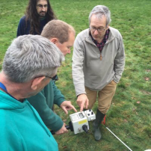 ning and Equipment) is a partnership between archaeologists at Bournemouth University and the New Forest National Park. Working with archaeological societies and community groups from across Hampshire and Dorset the project provides access, training, and support to advanced survey equipment that would otherwise be hard to obtain.
LoCATE aims to support the research that local groups already do by extending the range of techniques and skills they can apply to their own research. The goal is to enable an even greater contribution to the understanding of the rich archaeological heritage of our region. This is done specifically by providing access to equipment that is not always accessible to local groups. The current equipment that is freely available for groups to book out and use in their own time is a FM36 Magnetometer, a RM15 Resistivity meter and a Leica Flexline TS06+ 5” R500 Total Station. These have been supplied and maintained by Bournemouth University with funding support from the Hampshire Field Club, CBA Wessex and the New Forest Sustainable Communities Fund.
Bournemouth university and the NFNPA provide free training on the equipment for interested users.
If you are interested in joining LoCATE or accessing the equipment as a local group please contact us on the details below