

The New Forest Historical Landscape – Wessex Archaeology 1997
")
")
")
 holdings in the New Forest and surrounds, showing those with forest rights")


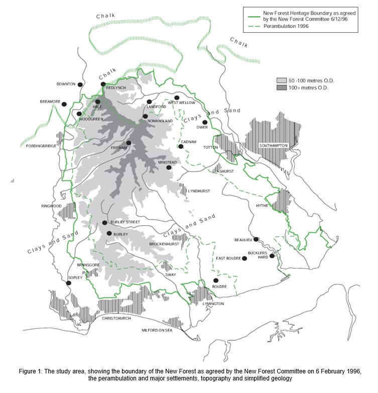
In 1996 the New Forest Committee, a non-statutory co-ordinating body with representatives of organisations and authorities which have responsibilities and interests in the management of the New Forest commissioned Wessex Archaeology to undertake a New Forest History Landscape Study. The physical scope was defined as the boundaries of the New Forest Heritage Area, which encompasses some 58,000 hectares. Its boundaries (Figure 1), agreed in February 1996 after a landscape study commissioned from LUC, were identified on the basis of two criteria: (i) the incorporation of land of outstanding national importance for its natural beauty and elements arising from human influences, and (ii) the incorporation of essential grazing land for backup to enable the continuing functioning of the dispersed pastoral regime of commoning. The original work was carried out by Wessex Archaeology between October and December 1996, and a technical report produced, with full methodologies, gazetteers and other supporting appendices (Wessex Archaeology 1996). This abridged version was compiled in December 1998.
Project Background
The New Forest has a unique traditional character. Its sense of place and character are a function of its history combined with its natural physical characteristics, which together form its cultural landscape. ‘Traditional character’ is a phrase frequently used in management and policy documents relating to the New Forest, but a definition of that character and the archaeological and historical elements which constitute it are less well stated.
One issue in such a study is that there is no generally agreed definition of ‘historic landscape’, and the word ‘landscape’ has different meanings to different people. It can, for example, mean a generalised or composite visual scene, an actual scenic view or a tract of owned and inhabited land. It can also be used to describe past landscapes interpreted by archaeologists or historians from incomplete datasets — all archaeology is about understanding the way in which people have interacted with and inhabited their own particular landscapes. But generally landscape is taken to relate to appearance and is highly experiential and personal.
There is little in the New Forest which could strictly be said to be natural, though nature has modified man’s impact. Most of its visible characteristics are the result of human activity, whether heathland developing as a result of prehistoric clearance, the settlement pattern or relics of past industry. An assessment of the New Forest’s archaeological and historical landscapes is therefore critical in understanding and managing the area. Therefore the principal purpose of this study was to attempt to examine what social and economic processes in the past have impacted on the area to produce its current unique traditional working landscape, and- to assist in the clearer articulation of the historical and archaeological elements that combine to characterise the present New Forest cultural landscape.
Specific aims and objectives defined for the study were:
• to identify the key archaeological and historic landscape elements that characterise the historic and cultural development of the New Forest, and
• to develop a methodology against which areas within or close to the New Forest could
be evaluated for their archaeological/historical associations with the New Forest.
In order to meet the aims set out above, a series of specific objectives were defined:
• to collate and examine the known archaeological resource and to collate information on geology, landform and hydrology in relation to the archaeology
• to describe the component elements, recurring components and recurring activities, in particular those which affect the physical nature of the land and which result in the landscape as it is seen today
• to examine the distribution of the components through time and spatially
• to assess the reliability of the present information for defining character
• to evaluate the nature of the archaeological and historical components in the New Forest and Avon Valley, and to compare or contrast the evidence in order to establish whether there are demonstrable links.
The New Forest Historic Landscape Study
This pdf has figures removed, but they can be seen in this article or retrieved by clicking on the following
LIST OF FIGURES
Figure 1: The study area, showing the boundary of the New Forest as agreed by the New Forest Committee on 6 February 1996, the perambulation and major settlements, topography and simplified geology
Figure 2: Archaeological sites and findspots (all periods)
Figure 3: Domesday (1086) holdings in the New Forest and surrounds, showing those with forest rights
Figure 4: General landscape types
Figure 5: Landscape types set against time-depth
Figure 6: Themes and distribution of dated sites and finds
Figure 7: Earliest recorded dates for selected settlements in the New Forest
Figure 8: Character Area – correlation of landscape types, time-depth and themes