

Exposed woodwork at Hurst Spit
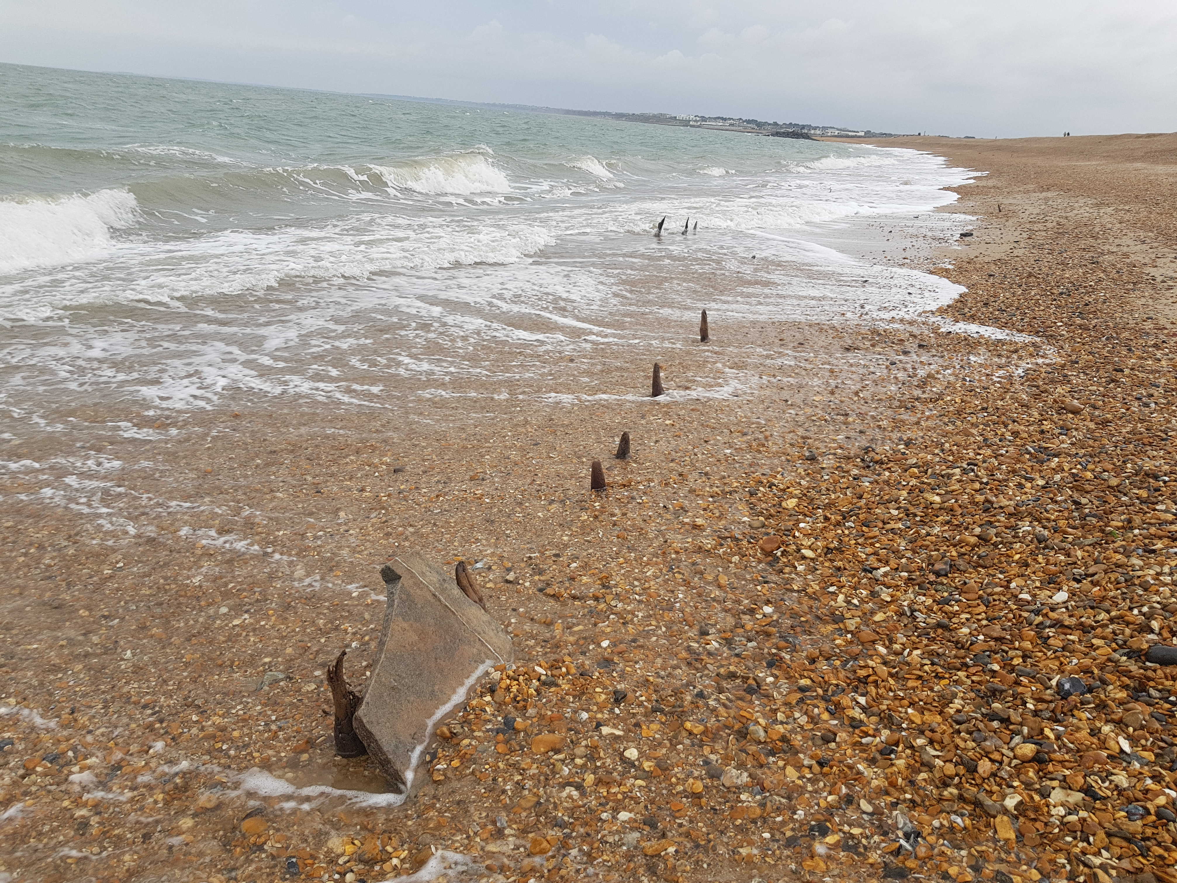


In October 2017 stormy conditions revealed a large amount of woodwork and stone slabs was reported by a member of the public on the seaward side of Hurst spit. After a few visits with New Forest District Council Coastal Team during which as many of the points were recorded Storm Brian made an appearance at the end of October and recovered the finds with gravel.
We then began the research to see what they might have been; old pier sections, bits of coastal defence or something more interesting. The big break through came when looking at an 1824 French coastal chart of the New Forest Coast based on a 1781 survey by Lieutenant Murdoch Mackensie available from Old Hampshire Mapped. Lt Murdoch MacKenzie’s uncle, Murdoch MacKenzie, was commissioned by the Admiralty, 1750, to make surveys of the coasts of Great Britain. He retired 1770 having done the coast of Ireland and the west coast of England down to Pembroke. Lt MacKenzie took over where his uncle had stopped, continuing south to the Bristol Channel and to Lands End; then surveying the Thames estuary. However the manuscript charts were not engraved for many years and were finally released to the public later in the 19th century.
The coastal Chart records a Saltern set behind Hurst Spit with its own wind pump, though it is marked as a ruin. When we geo-rectified this chart onto modern mapping and then overlaid the points recorded NFDC they aligned with the northern edge of the marked saltern. As well as the lines of vertical timbers there were also groupings of vertical stakes recorded which roughly tie in with the location of the marked wind pump marked on the map.
Further research and conversations brought to light a series of photos taken by Jude James in 1989 that showed more lines of vertical timber supporting stone slabs exposed on the seaward side of Hurst Spit, which was the old southern edge of the saltern.
In Daniel Defoe’s 1704 book ‘The Storm’ used accounts sent in from people across the country to record and popularise the great storm of 1703. Across the New Forest some 4,000 oak tress were lost in the storm and a letter from Mr James Baker in February 1704 recorded the following amongst other observations: By the flowing of the Sea over Hurst Beach, two Salt-terns were almost ruin’d belonging to one Mr. Perkins. The only salterns these could be are the ones identified on the Mackenzie Chart.
Another source of information was the work of one of our volunteers: Wiseman, W. 2001: The Lymington Salt Industry, Hampshire: An Appraisal. Unpublished Undergraduate Dissertation, King Alfred’s College, Winchester. The saltern in question is known as Gates Saltern, that later becomes known as ‘The Mount’. The saltern was originally situated well to the east of Hurst Spit up to 1720, but by 1758/9, the shingle had moved up to the saltern’s seawall. When the sea breached the spit, part of the site was destroyed by flooding. This happened again in 1774/5, causing works to close until 1777. Further flooding occurring in 1778/9, led to the site finally being forced to close down in 1781. By 1797 only rubble was left on the site, which was visible until 1989, when a violent storm rolled the spit right over the site and it became exposed on the seaward side. The site was then recorded as either lost to the sea or reburied, luckily recent reveals show it was the latter. It is also very possible that the saltern here was linked with the 6 salinae’s recorded in the Doomsday book; none were recorded at Lymington, but they were recorded at Hordle, which is interesting as the present day parish does not extend far enough east to take in land suitable for salt making. However, until the middle of the 20th century Hordle parish did extend eastwards to include Hurst Spit. The Salterns recorded in Doomsday, were presumably those which lay in the original lee of the shingle bank.
Using the scale on the chart suggests that Hurst spit has rolled back a little less than 1/8 of a nautical mile which would roughly translate into about 200 metres.
By the end of October the woodwork had been re-covered by shingle movement, but was once again visible in April 2018 with a few more timbers missing.
If you have any photos of exposed woodwork or features at Hurst or even places like Calshot or Milford please do get in touch.
You can find out more about the New Forest salt industry and it’s history in this overview article: New Forest Salterns – An Overview