

Woodfidley Crossing and Figure of 8 track
Woodfidley forestry level crossing across South Western main line north of Beaulieu Airfield. In the 60s there used to be a small signal box here controlling access to sidings in the clearing for loading tanks / supplies for D-Day. The signal levers were still in the box long out of use.There are remains of the concrete apron in the clearing. They show upon Google Sat View. I wonder if there are any photos?
Since Alan posted this he has found a website ‘Name that station…from the air‘ which may give additional information ref’ the sidings query. This site has links to further detailed information including photos and track plans for those interested.
You can visit the web site by clicking here: “More Info“. (Please note this is an external site and we are not responsible for its content.)
The Figure of 8
This can be seen from the train as you pass Woodfidley, what is it?
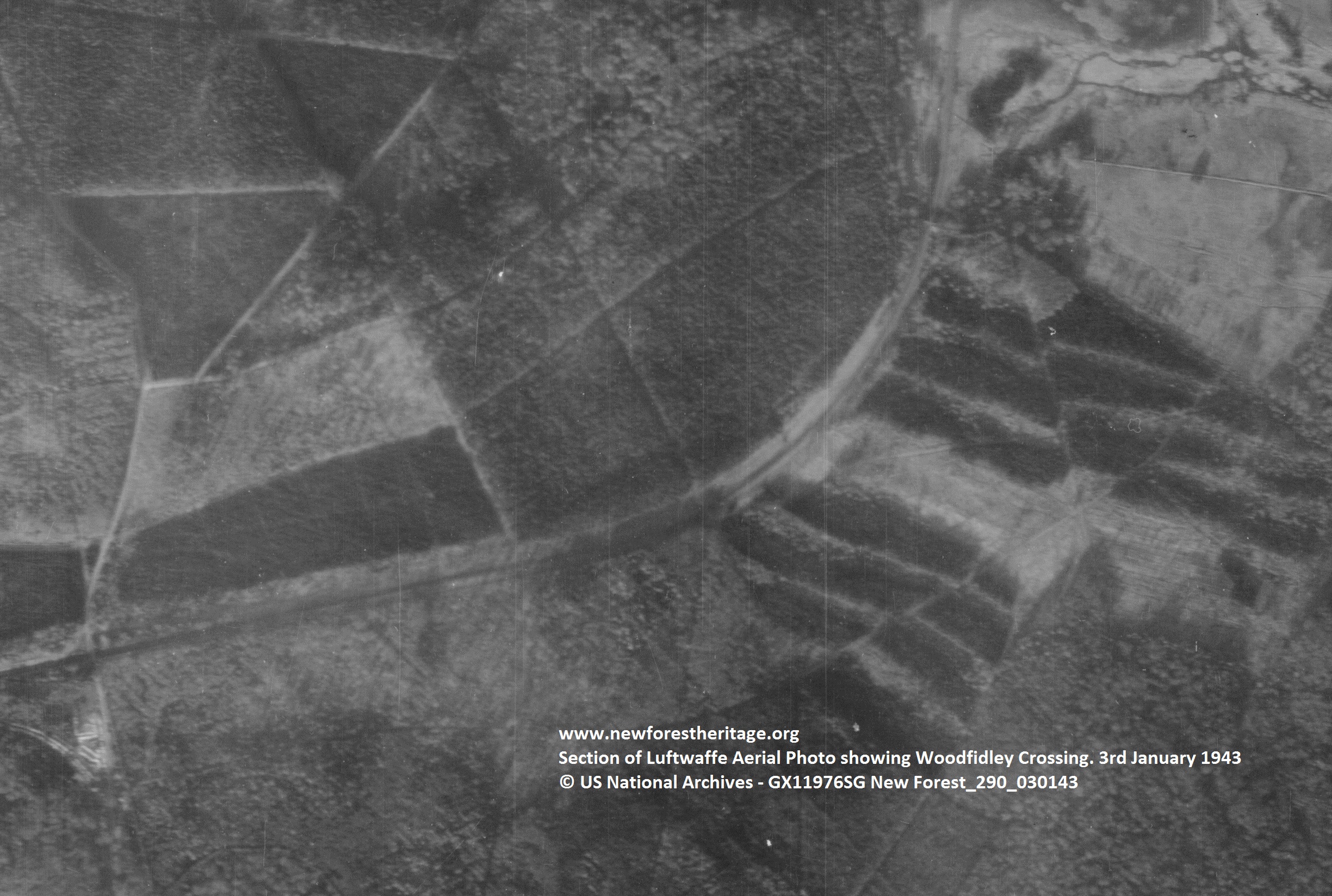
In the section of Luftwaffe aerial photo this section of the mainline is clearly visible. In the area of Woodfidley Crossing the “figure of 8” feature is not visible. This photo is dated 1943 so any structure here must have been built after this date.
A similar site can be seen at Denny Campsite.
They are the result of post war experimentation. During the 1950’s & 60’s the Forestry Commission started upgrading the timber extraction tracks in the Forest by making new gravel tracks around the inclosures. The needed to experiment on the mix of sand, gravel and clay so they could find out what was most hard wearing.
As such they laid out this concrete circuits which had patches in the central section which could be laid with the experimental mixes. A lorry would then be set to driving over and over the mix again and again with the turning circles at each end to prevent the need for lots of manoeuvring each time they got to the other end.
At the Woodfidley one you attached to will note a little to the west is an oblong pond, this is where they dug the clay from for the experiment. Possibly the Sand came from the sand pit at Denny as to the gravel I’m not sure.
Search terms: Woodfidley Crossing
Hi Alan,
Are you talking about the figure of 8 looking feature north of the railway line or some of the hardstanding running along the south of the line?
We have heard numerous stories and ideas about the figure of 8 feature just North of the line running east-west at this point, but there is nothing visible on 1946 RAF Aerial Imagery, though it is very clear of Google Earth, we were not sure if this was something more modern relating to the railway activity or other activties in the New Forest
As an update
If we are talking about the tracking to the north of the railway line.
A similar site can be seen at Denny Campsite
They are the result of post war experimentation. During the 1950’s & 60’s the Forestry Commission started upgrading the timber extraction tracks in the Forest by making new gravel tracks around the inclosures. The needed to experiment on the mix of sand, gravel and clay so they could find out what was most hard wearing.
As such they laid out this concrete circuits which had patches in the central section which could be laid with the experimental mixes. A lorry would then be set to driving over and over the mix again and again with the turning circles at each end to prevent the need for lots of manoeuvring each time they got to the other end.
At the Woodfidley one you attached to will note a little to the west is an oblong pond, this is where they dug the clay from for the experiment. Possibly the Sand came from the sand pit at Denny as to the gravel I’m not sure.