

Airborne Lidar (Light Detection and Ranging)


How Lidar works
Interpreting the ‘lumps and bumps’ on the landscape can tell us a lot about how the New Forest has been used and exploited since the Neolithic period.
Finding and recording archaeological features through traditional field survey can be difficult and time-consuming for archaeologists: using such techniques it is estimated that it might be more than 100 years before we have an understanding of the number and range of sites.
Airborne Lidar (Light Detection and Ranging) makes it possible to speed up the process. It is a remote sensing technique that allows a very detailed digital surface model of entire landscapes to be constructed.
A pulsed laser beam is scanned from side to side from a plane as it travels over the terrain, recording thousands of three dimensional points to the ground every second. These pulses reflect off the ground and are received by detectors on the plane, which calculate the distance between the plane and the ground using the known speed of light coupled with the accurate positioning of the plane.
It is possible to gather millions of these exceptionally accurate measurements that can then be processed to create a surface that is an accurate model of the landscape.
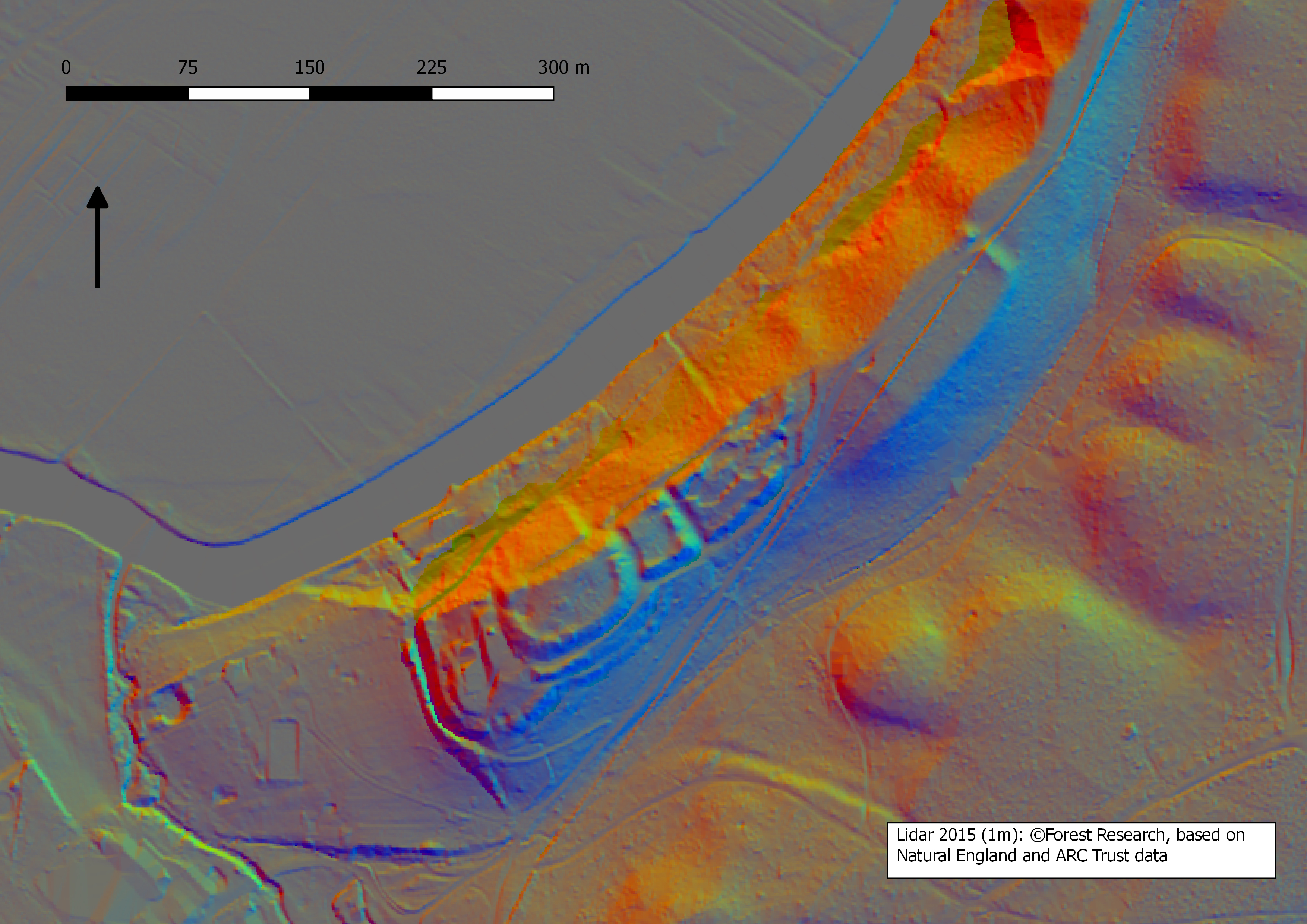
How Lidar helps
Traditional archaeological survey is often difficult in woodland as vegetation makes sites impossible to reach, see and record. Lidar’s ability to ‘see through’ vegetation is one of its main strengths.
Because the laser pulses can filter between the leaves and branches of trees, we are able to strip away the vegetation and look at the ground – and the archaeology beneath the tree canopy – often with spectacular results.
We can also digitally manipulate the Lidar to produce a range of images by illuminating the model in different ways, examining slope and aspect, viewing in 3D and drawing sections across the landscape.
We can also combine the Lidar with other information, such as historic mapping dating back to the 18th century, aerial photography, near infrared imagery and records of known archaeological sites.
All of these techniques help us to accurately identify and interpret sites, which can then be checked on the ground.
Hidden History – Lidar 3D Mapping
How laser mapping is used
Because Lidar data can be manipulated in a number of ways it is incredibly versatile and its uses are not limited to archaeology.
Lidar can be used to identify veteran trees which are of great ecological and historical significance. In processing the Lidar it is possible to remove the landscape to leave just the trees. These can be examined to identify trees of a desired height, form and crown width to isolate potential veteran tree candidates.
Combined with near infra-red imagery and aerial photography we can even focus on particular species. Similar processes can be used to monitor scrub growth or erosion and identify particular habitats.
LiDAR provides valuable information for land management, grazing schemes and stream restoration projects and also helps to identify ‘palaeochannels’ (the remnants of old river systems).
Explore laser map
View the tiled Lidar map of the National Park
In its most basic form, 3D Lidar data allows us to create a detailed model of the earth’s surface within the New Forest National Park. The data also allows us to remove any tree cover seen throughout the forest and look at the topographical changes seen beneath the trees.
The Lidar data is gathered through the use of a laser scanner recording 3D points during a flight over the landscape. Both the Lidar maps and Lidar zoom pages show a combination of hill shade analysis of this raw Lidar data.
By creating artificial light sources on the landscape (azimuths) on a computer, the data can show where shadows would be created by the lumps and bumps seen on the earth’s surface.
Although buried archaeological features cannot be identified, anything seen breaking the ground surface or above it do show up.
View the zoom Lidar map of the National Park.
Explore near infrared map
Near infrared records a band of light not visible with the human eye. It has been captured using an infrared camera during Lidar flights.
The camera looks at a different spectrum of light to that which we normally see with the naked eye.
Differing moisture levels, ground density and varying vegetation coverage seen on the earth’s surface absorb this light in different ways, and this variation can be used to identify archaeological and environmental features.
Explore the whole National Park and surrounding area in infrared.